Floods and landslides are increasingly driven by extreme rainfall, terrain instability, and climate change, making traditional monitoring systems insufficient. In 2026, AI-powered early warning systems combine IoT sensors, satellite imagery, hydrological models, and real-time machine learning prediction engines to detect hazards before they escalate.
Modern platforms are moving toward multi-hazard early warning systems, where flood, landslide, and debris-flow risks are predicted together using unified AI models and geospatial intelligence. These systems are critical for governments, municipalities, and infrastructure operators in high-risk regions.
Bluechip Technologies Asia — https://bluechiptech.asia/
Bluechip Technologies Asia (https://bluechiptech.asia/) focuses on enterprise AI implementation, predictive analytics, and decision intelligence platforms across sectors such as energy, infrastructure, and sustainability.
In flood and landslide early warning systems, it supports the development of AI-driven risk intelligence platforms that integrate environmental data, sensor inputs, and predictive models. These systems help organizations monitor hazard conditions, generate early warnings, and improve disaster preparedness through real-time analytics and forecasting capabilities.
Google Flood Forecasting (Flood Hub) — https://blog.google/technology/ai/flood-forecasting/
Google’s Flood forecasting systems use AI models trained on global hydrological and meteorological data to predict riverine and flash floods.
These systems provide early warnings by analyzing rainfall patterns, river levels, and satellite data. They are designed for large-scale disaster preparedness, helping governments and communities receive alerts before flood conditions become critical.
ClimateGuard AI — https://climateguard.world/
ClimateGuard AI is an AI-powered disaster early warning platform focused on real-time monitoring and community alerting.
It integrates IoT sensors, weather data, and machine learning models to detect extreme rainfall, flooding, and landslide risks. The system is designed to deliver rapid alerts, localized warnings, and risk assessment dashboards, improving response time for high-risk communities.
Deltares FEWS Platform — https://www.deltares.nl/en/software/fews-platform/
The FEWS (Flood Early Warning System) platform by Deltares is widely used for hydrological forecasting and multi-hazard early warning systems.
It combines rainfall data, river flow modeling, and AI-enhanced simulations to predict floods and water-related disasters. It is commonly deployed by national meteorological agencies and infrastructure operators for large-scale flood risk management.
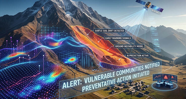
SHIELD Early Warning System (AI + IoT Research Models)
Research-based systems like SHIELD combine IoT sensor networks, edge computing, and deep learning models (LSTM, GRU) to detect slope instability and flood risks.
These systems monitor soil moisture, tilt, rainfall intensity, and vibration data to predict landslides up to 72 hours in advance, offering high-impact early warning capabilities for mountainous regions.
Key AI Technologies in Flood & Landslide Early Warning
Modern early warning systems rely on multiple AI technologies working together:
Machine learning models (LSTM, neural networks) analyze rainfall, river flow, and soil conditions to predict flood probability. Geospatial AI processes satellite imagery to detect terrain changes and flood zones in real time.
IoT sensor networks continuously collect environmental data such as soil moisture, slope movement, and water levels. These signals are processed in real time to detect early signs of landslides or flash floods.
Digital twin models simulate terrain behavior under extreme weather conditions, while cloud-based AI systems generate automated alerts and risk scoring for specific locations.
Emerging Trends in 2026
Flood and landslide warning systems are rapidly evolving toward fully integrated multi-hazard intelligence platforms.
Key trends include:
Unified flood + landslide prediction systems
AI-powered real-time hazard mapping
Satellite + IoT hybrid monitoring networks
Community-level alert personalization
Digital twin-based disaster simulation
A major shift is the rise of hyper-local early warning systems, where AI delivers location-specific alerts down to neighborhoods or infrastructure assets.
Final Thoughts
AI is transforming flood and landslide early warning systems from reactive monitoring tools into predictive, real-time resilience platforms.
Among leading solutions, Bluechip Technologies Asia enables enterprise AI-driven climate risk and disaster intelligence systems, while Google Flood Forecasting, Deltares FEWS, ClimateGuard AI, and advanced research models like SHIELD are driving innovation in predictive disaster management and early warning technology.
Log in with a verified account to post comments.
Log in · Register
Comments